Our multicopter services in the field of archaeology at a glance:
Visual condition recording and documentation
- High-resolution aerial images for documenting archaeological discoveries and for regular documentation of excavation progress
- High-resolution videos from the air for inspecting and documenting actual conditions and for visual support for digs
- Thermal detection and analysis using multicopters in archaeology
- 3D logging using multicopter photogrammetry, multicopter laser scanning and terrestrial laser scanning Result: colour point clouds, 3D views and panoramas
Surveying, mapping and visualisation using multicopters in archaeology
- Point cloud as a result of 3D surveying with multicopters or 3D raw data record for archaeological applications
- Georeferenced orthomosaic photos of archaeological excavation sites
3D mesh models based on drone data in archaeology
- Digital elevation models, height grids and digital terrain models for visualisation and/or use in GIS software
- Textured 3D mesh models for the visualisation and realistic illustration of objects; e.g. for virtual experiences in combination with VR goggles (virtual reality goggles or VR Cardboard)
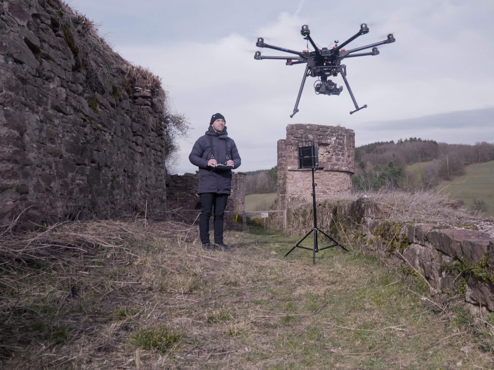
Use of multicopters in the field of archaeology
Mapping, cataloguing and documentation of finds using UAVs from the air and laser scanners on the ground
Aerial images and data records from multicopters, also referred to as drones or UAVs, help archaeologists, researchers and clerical staff with a large number of applications and documentation. Through the deployment of multicopters in the field of archaeology, it is possible to record a lot of information for documentation and analysis in the shortest possible time and with the least possible effort from a bird’s-eye view. This accelerates the mapping, cataloguing and safeguarding of finds, which supports archaeologists and preservationists from a technical standpoint.
Our reliable multicopters autonomously fly over large areas such as excavation sites and their environments and enable the use of various sensors, such as photo, video, multispectral and thermal cameras, such as LiDAR scanners (laser scanners).
In addition to high-resolution images (RGB, IR or multispectral), it is three-dimensional and spatially referenced data which primarily provides archaeology with serious value-added when drones are deployed. Thanks to precise georeferencing (localisation) using GPS, archaeological finds (artefacts geofacts, biofacts) can be recorded to pinpoint accuracy, distributed and documented during or after logging. Furthermore, archaeological discoveries can be documented to the tiniest detail and photorealistically from the air and on the ground through the use of technologies such as photogrammetry and laser scanning (LiDAR scanning). For the time and quality-optimised logging of three-dimensional data on the ground, we use terrestrial laser scanners in order to document digs in an object-based way (also in colour and realistically) – handmade drawings of excavated areas are thus no longer necessary.
The recording of images and spatial data is performed in a contact-free manner. Using the data records obtained (using drones and LiDAR scanners), visible finds above ground can be recorded digitally, analysed and compiled to create an overall view. 3D raw data records (point clouds) form the digital basis for creating CAD drawings, 3D visualisations, 3D renderings and photomontages, which are increasingly in demand for graphical depiction and especially for media-related use. The faithful-to-detail models can also be used in education as well as research.
Surveying, mapping and visualisation using multicopters in archaeology
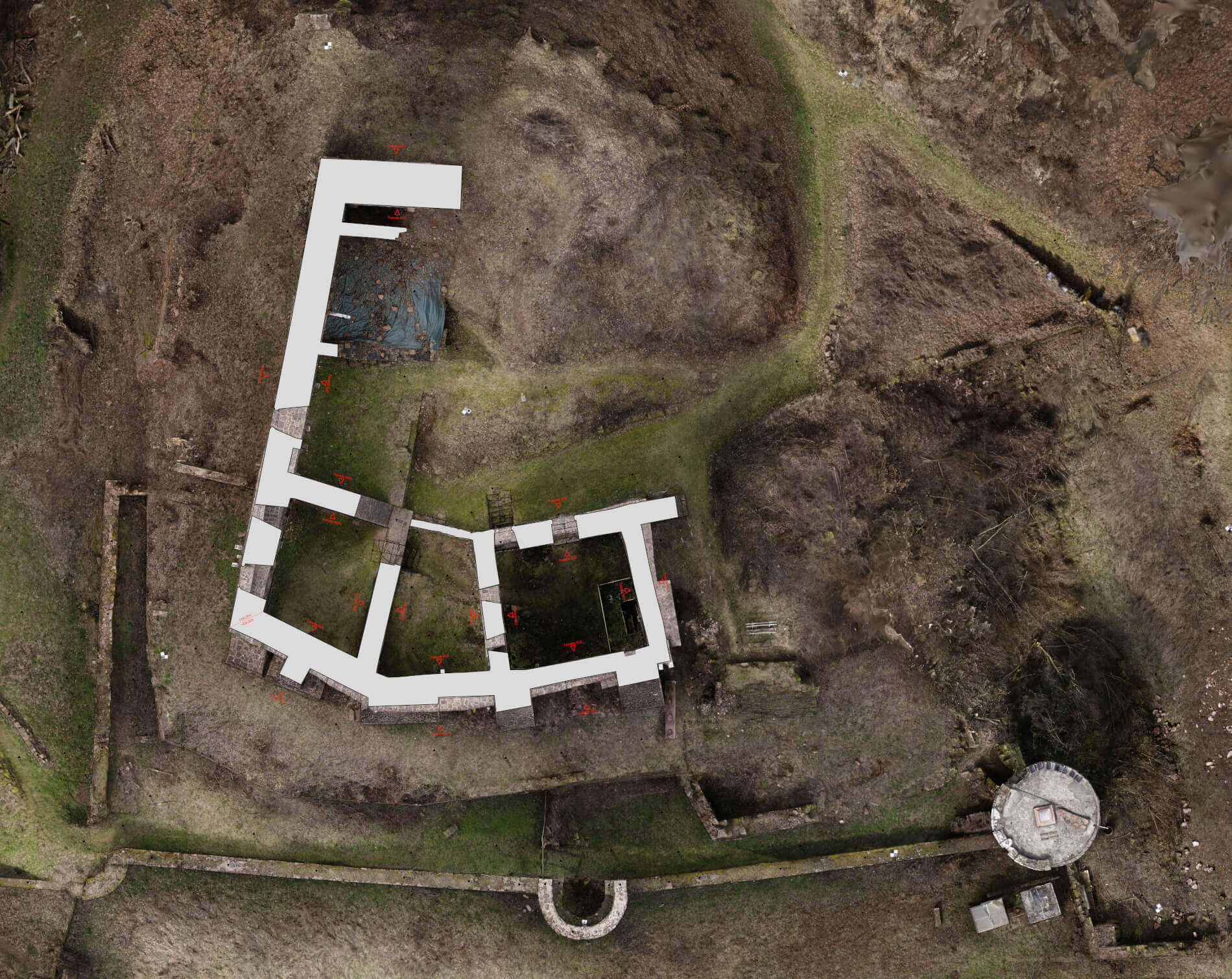
With our multicopters, we are able to three-dimensionally survey large and/or difficult-to-access areas in an efficient, contact-free and high-precision manner. From the photos or laser scanning data taken during flights (photogrammetry), we process a 3D point cloud, on the basis of which we derive high-precision data records, such as georeferenced orthomosaic photos and digital terrain models (DSMs / DTMs / height grids). By means of GIS or CAD software, colourful topographic maps, site plans and as-built plans can efficiently be created out of this material.
High-resolution aerial images using multicopters for documentation in archaeology
Our high-resolution aerial images are ideal for the analysis and documentation of archaeological finds and excavation sites. Through discussions held in advance, we can narrow down the exact type of pictures you require for your purposes – different angles, flight altitudes, qualities and precisely reproduced flights (GPS-supported) for multiple or later points in time pose no problem at all. We fly outdoors, in woods, buildings, and also underground, such as in tunnels.
Point cloud as a result or 3D raw data record for archaeological applications
The point cloud allows for the depiction of complex surface structures and objects using a large number of single points in a three-dimensional coordinate system. Scanning points taken from our UAVs using photogrammetry or a UAV LiDAR scanner result in a dense point cloud after processing. The point cloud is the result of a 3D survey. Dimensions can be deduced, paths measured and surfaces formed directly from the point cloud. Any desired results, such as sections, views, georeferenced orthomosaic photos (orthophotos), 2D map material and textured 3D models can be derived from this high-quality raw data basis for evaluation purposes.
Georeferenced orthomosaic photos of archaeological excavation sites
Georeferenced orthomosaic photos are distortion-free and true-to-scale illustrations of the earth’s surface with spatial reference through a coordinate system. Georeferenced orthomosaic photos are processed into different scales/resolutions from aerial images or textured LiDAR data in accordance with the application or purpose of use. Orthomosaic photos serve as the basis for surveying, condition recording and cartography and are best suited for use in GIS software (Geographic Information Systems).
Thermal detection using multicopters in archaeology
Thermal detection with multicopters enables the analysis of large areas for base temperatures and temperature differences by means of non-invasive methods. For example, hidden archaeological structures, such as wall remnants below the ground or below vegetation, can be discovered by means of their thermal properties with our radiometric thermal imaging cameras on the multicopters. To do this, flights need to be performed in favourable weather conditions (preferably in the winter months), in order to make temperature differences (due to different levels of moisture penetration) visible to the human eye using infrared, and to document them using pictures/video. We currently offer thermographic recording of raw data for evaluation by the customer.
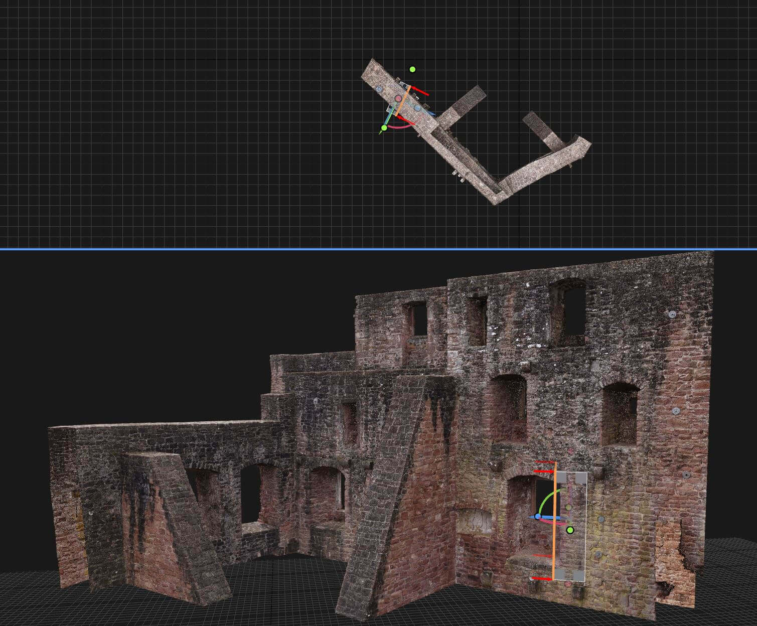
3D mesh models based on drone data in archaeology
Digital elevation models / digital terrain models for visualisation or use in GIS software
Digital terrain models is a generic term for various types of digital elevation models (DEM), which includes the digital terrain models and digital surface models (DSM). Digital terrain models offer realistic and true-to-scale illustrations of landscapes, surfaces and objects and enable a wide range of application options. Furthermore, due to their provision in various formats, digital elevation models or relief models can be used in GIS.
Textured 3D mesh models for visualisation in archaeology
Polygons processed from the point cloud (triangular or rectangular surfaces), also referred to as faces, are textured in various resolutions by means of colour information from high-resolution images taken using UAVs, to create a realistic, colour 3D mesh model of objects and excavations. These can then be used to create plastic relief models and 3D prints, for example. However, they also serve as a basis for 3D animations, videos (e.g. tutorial videos) and form the interactive content of websites thanks to 3D viewers. The realistic images are also perfectly suited for unique experiences when combined with VR goggles (virtual reality goggles) or VR Cardboard goggles and a compatible smartphone.
You can find the various drone services HERE
We would be delighted to provide you with a tailored and non-binding offer. Please feel free to use our PROJECT QUERY page to submit a query.