Our UAV services for landfills, dumps, stockpiles and open-pit mining at a glance:
3D surveying with UAVs using UAV photogrammetry and UAV laser scanning
- 3D measurement and 3D surveying with drones using drone photogrammetry
- Point clouds as a result of 3D surveying / 3D documentation
Volume calculations and quantity surveying – 3D measurement and documentation from one source
- Regular documentation of volume and quantity movements, development and subsidence
- Difference comparison of quantity changes (delta calculation)
- Data logging for inventories and accounting for stock levels (value determination)
- Target/actual comparisons for inspections
- Calculating filling volumes
- Calculating and determining removed and added volumes and volume orders
- Monitoring slope movements
- Cubature calculations
Data for GIS applications, mapping and 3D models
- Georeferenced orthophotos of the earth’s surface in various scales and resolutions for documenting and/or overview
- Digital elevation models (DEM), digital terrain models (DTM) and digital surface models (DSM)
UAV surveying
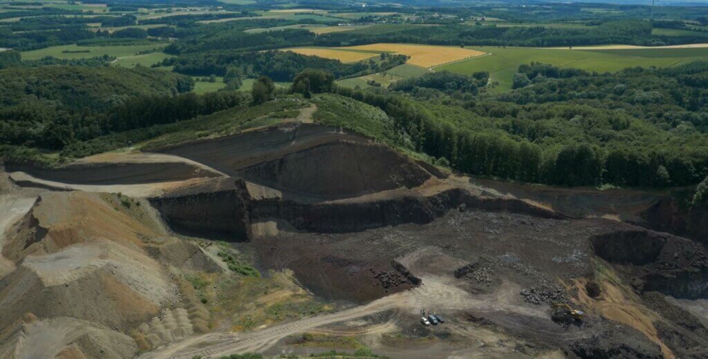
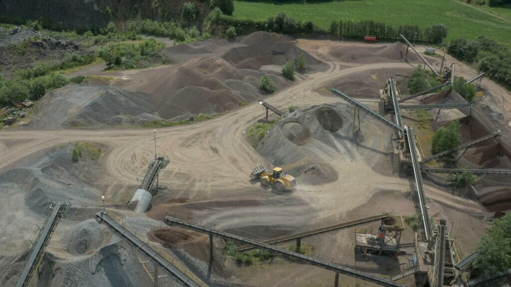
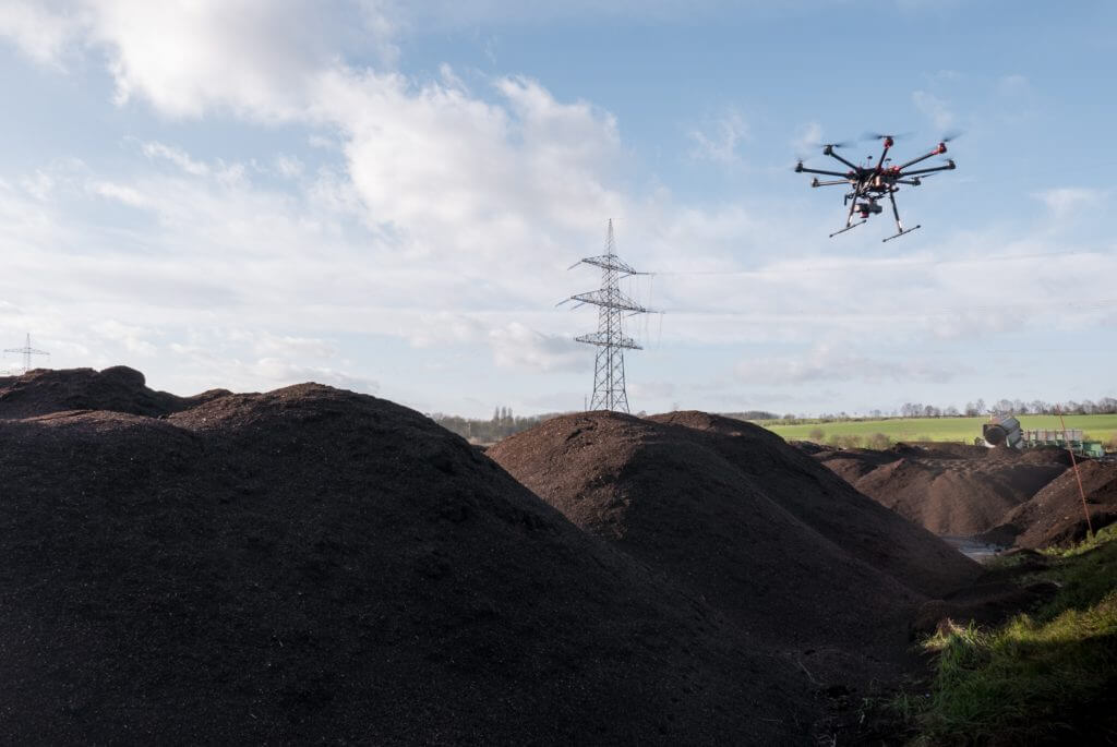
By using UAVs for the surveying of stockpiles, gravel pits, landfills, composting facilities, open-pit mining and quarries, not only efficiency, but also the safety of all persons and employees involved is elevated. It is no longer necessary for people to have to enter hazardous areas to capture three-dimensional digital surface data. Recording on inaccessible terrain or during operation is easily possible. By means of contact-free and fast logging, we deliver cost-effective, precise CAD and GIS-compatible data, such as length and height recordings, georeferenced orthomosaic photos and digital terrain models (DSM / DTM / height grid). As a result, we offer the following data records: 3D point clouds, orthomosaic photos, DTMs or complete numerical documentation of the volume or delta (volume changes)
Volume calculation and quantity surveying using UAV data logging
Through contact-free, three-dimensional gathering using UAVs, we cost-effectively deliver precise volume calculations and quantity surveying for documentation purposes and for visualisation. By doing two or more flights at different times we can document an exact delta (difference comparison) of volume changes. Target/actual comparisons after two successive flights are also effortlessly possible.
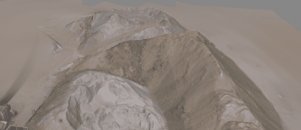
The data records are frequently used for inventories and accounting, but also play a big role in supplying a wide variety of documentation and for submitting applications; for example, in relation to renaturation measures or the expansion of excavation or storage areas. We process high-precision 3D volume models (using 3D meshing based on a point cloud) in the shortest possible time and, in addition to three-dimensional logging, we also offer full data evaluation. This gives you numerical documentation of a given volume for quantity surveying. The handover of raw data (point cloud or 3D mesh model / wireframe model) for external evaluation is also possible. Furthermore, we produce an orthomosaic photo if it is necessary for orientation, visualisation or for defining materials and/or storage spaces.
Point clouds
A point cloud is a set of individual measurement points in a three-dimensional coordinate system, which is usually defined by X, Y and Z coordinates. The high density of the point cloud enables the depiction of complex surface structures, objects and the earth’s surface. The point cloud is already the result of a measurement or 3D survey. Dimensions can be deduced, paths measured and surfaces formed directly from the point cloud.
Georeferenced orthomosaic photos (orthophotos)
Georeferenced orthomosaic photos are distortion-free and true-to-scale illustrations of the earth’s surface with spatial reference through a coordinate system. Georeferenced orthomosaic photos are processed into different scales/resolutions
from aerial images or textured LiDAR data in accordance with the application or purpose of use. Orthomosaic photos serve as the basis for surveying, condition recording and cartography, as well as a data record for GIS software (Geographic Information Systems). With respect to stockpiles, gravel pits, landfills, biomass plants and quarries, orthomosaic photos are frequently used for orientation, planning, documentation or for defining different materials (e.g. for volume calculations).
Digital elevation and terrain models
Digital terrain model is a generic term for various types of digital elevation models (DEM), such as the digital terrain model (DTM) and the digital surface model (DSM). The different types of digital terrain models offer varied but always realistic and true-to-scale illustrations of landscapes, surfaces and objects while also offering numerous application options. We generally supply digital surface models, for these provide an illustration of real conditions, whereby not merely the earth’s surface, but also elements located on it, such as vegetation and buildings, are also depicted. If just the height structure of a terrain is of importance, we process and provide a digital terrain model (DTM) to the required grid on which irrelevant elements, such as vegetation and buildings, are not depicted.
Using surface data in geographic information systems
Like orthomosaic photos, digital terrain models (DTM) and digital surface models (DSM), UAV data is intended for use in geographic information systems (GIS software) and can be output in all common formats. The spatial data logged through UAV flights can thus be interpreted, managed, processed and evaluated effortlessly in GIS. Optimum size and resolution is decisive for efficient use of geodata from the air in GIS software. This is why discussing all data formats and quality requirements beforehand, in order to be able to work with it systematically and efficiently following logging, is of crucial importance.
You can find the various drone services HERE
We would be delighted to provide you with a tailored and non-binding offer. Please feel free to use our PROJECT QUERY page to submit a query.