Our UAV services for the construction industry and the civil engineering sector as a glace
Surveying and modelling
- 3D measurement and 3D surveying with drones by means of drone photogrammetry, drone laser scanning and terrestrial laser scanning
- Point clouds resulting from 3D surveys / 3D documentation using UAVs
- Orthomosaic photos from different recording angles; e.g. of façades, towers or bridges (recording from bottom to top)
- Georeferenced orthomosaic photos of the earth surface in a wide variety of scales and resolutions
- Digital terrain models, including digital elevation models (DEM), digital terrain models (DTM) and digital surface models (DSM)
- Volume calculation and quantity surveying using UAVs
- BIM data logging and BIM modelling (Building Information Modelling) based on UAV and/or LiDAR point clouds
- 3D modelling and 2D drawings based on UAV and/or LiDAR point cloud
- 3D façade documentation using drones
Building documentation in 2D, 3D and visual construction site monitoring using UAVs
- High-resolution aerial images from drones for documenting the actual condition of objects and buildings
- High-resolution videos from the air for documenting actual conditions and for marketing/sales purposes
- Construction progress documentation and construction site monitoring for presenting project progress
- 360° recordings, panoramas and views from various viewing angles based on 360° stitchings (VR camera use), individual images or 3D point clouds.
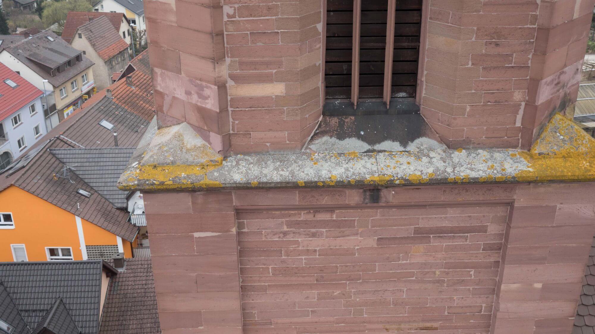
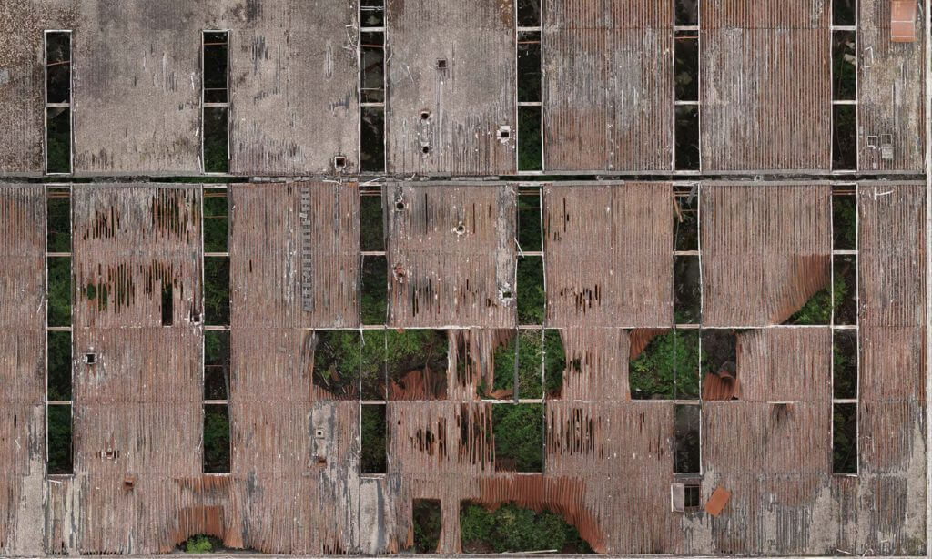
Inspection and documentation of buildings
- High-resolution aerial images from drones for inspecting and documenting the actual condition of objects and buildings
- Aerial thermography for documenting actual conditions and thermographic evaluation using radiometric data.
- Façade documentation using UAVs
- Bridge documentation using UAVs
- Roof inspections using UAVs
Surveying and modelling for the construction industry
UAV surveying
Whether it is infrastructure or building above/below ground level, we are able to gather survey data quickly and flexibly, to process it according to requirements and to supply it in all common data formats. From the data taken during flights, we process a 3D point cloud, on the basis of which we process high-precision data records, such as georeferenced orthomosaic photos and digital terrain models (DSMs / DTMs / height grids) for the construction industry. By means of GIS or CAD software, topographic maps, site plans and as-built plans can be created out of this material efficiently and colourfully.
Georeferenced orthomosaic photos from UAV data
Orthomosaic photos are distortion-free and true-to-scale images of the earth’s surface. Georeferenced orthomosaic photos also have a spatial reference through a coordinate system. The opportunities for using georeferenced orthomosaic photos are highly diverse and range from surveying, cartography, use in GIS software (geographic information systems), use in rural and urban planning, right through to visualisation. Orthomosaic photos are produced in accordance with the purpose of use to various scales and resolutions for the construction industry.
3D bridge surveying using UAVs
With modern technology many years of UAV experience and know-how, we ensure the quick, high-precision and contact-free logging of the entire bridge. A very high point density helps in drawing 3D CAD models or plans based on the point cloud or the CAD data gained from it. Depending on project requirements, we use various methods – a combination of photogrammetric gathering and LiDAR scanning (UAV LiDAR or terrestrial scanners) is seamlessly possible.
BIM – Building Information Modelling based on UAV and laser scanning point clouds
Building Information Modelling (BIM) describes an interdisciplinary method for optimum planning, creation, execution and administration of buildings in civil engineering. All relevant building data from the CAD plan and reality is digitally modelled, combined and recorded in the BIM software. Data can be captured from the air in a cost-effective way using UAVs. Data taken from the ground can be enhanced by / combined with drone data seamlessly to improve the quality of the model considerably.
Volume calculation and quantity surveying using UAVs
When planning large construction and infrastructure projects such as roads, halls or parks, the excavating and filing of earth must be calculated precisely in the individual project phases. By using drones, we are able to capture large surfaces, building land and objects located in the implementation phase three-dimensionally in an efficient, contact-free and highly precise manner in order to document an exact volume and quantity calculation of actual conditions. By doing two or more flights at different times we can document an exact delta (difference comparison) of volume changes. Therefore, target/actual comparisons do not pose any problems. Calculation and accounting programs (e.g for working with forecasted billing quantities) can use the digital data. However, the data records can also be used directly for BIM applications.
3D building documentation and visual construction site monitoring with UAVs
3D documentation of construction progress from the air using UAVs
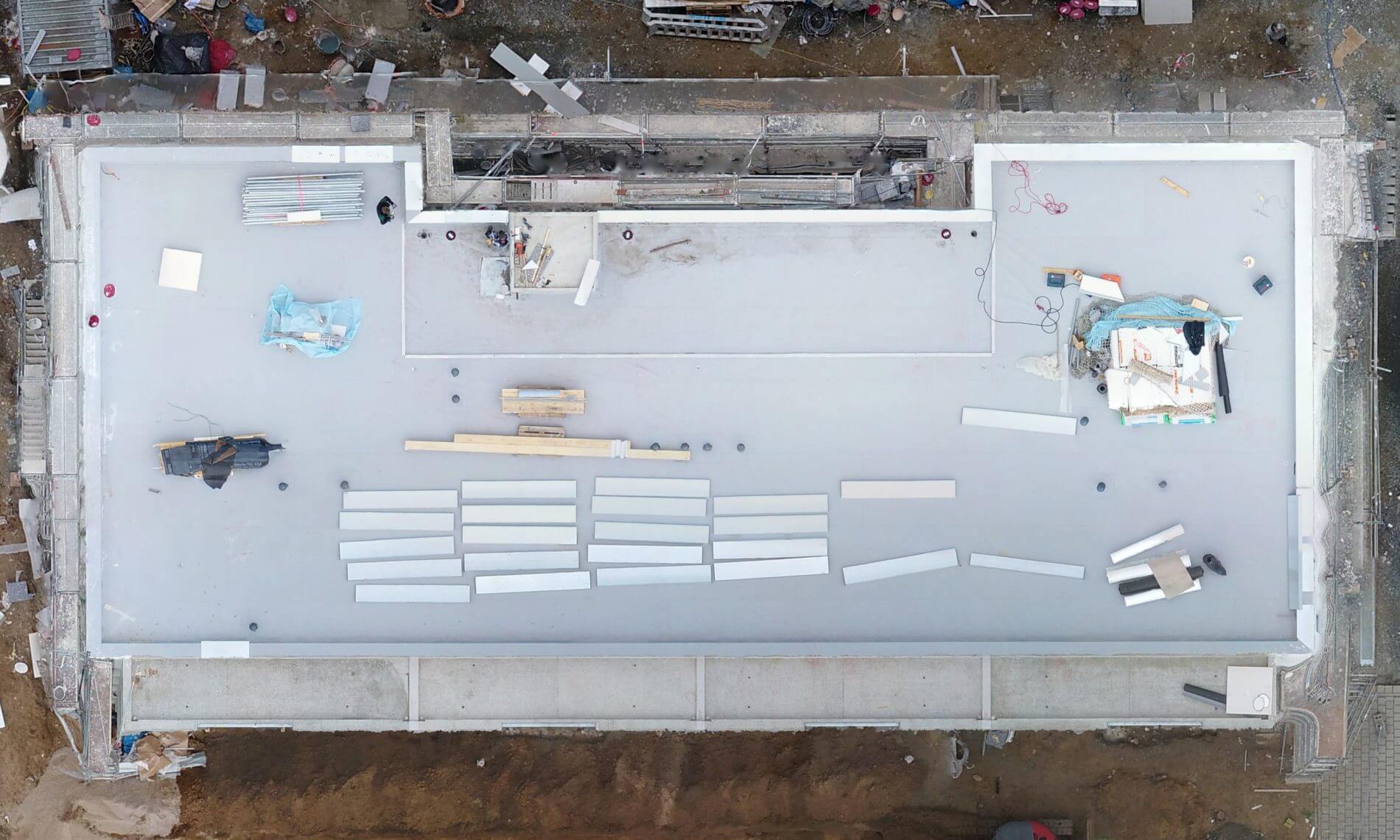
We offer start-to-end 3D data logging for the 3D documentation of building progress based on UAV point clouds. Data logging is performed using UAVs and offers continuous, colourful and precise data records from the earliest project phase (e.g. 3D measurement to conception) across all stages through to project completion and beyond. All data records are based on common point cloud formats which can be combined seamlessly with point clouds from other sensors/scanners (e.g. terrestrial laser scanners). Due to the quality available, in addition to technical applications, the point clouds can also be used for media-related purposes, because they depict natural colours from which detail-rich views, 3D models or tours can be generated.
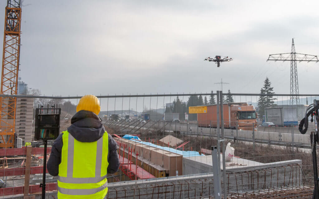
Visual construction site monitoring using UAV images
We offer you different solutions relating to construction site monitoring to support your project fittingly and to present it visually and effortlessly by means of images (regular or 360° / VR) and videos. The image and/or film material for the construction site monitoring can be created in such a way that you can use it later on for marketing purposes. You can shape your project more vividly for potential customers and the public. With the aid of aerial images, you can obtain previously unknown levels of transparency concerning the progress, status and development of your construction project. We offer new ways for the civil engineering and construction industry.
Inspection and documentation of buildings for the construction industry
Inspection of buildings using UAV cameras and UAV thermal imaging cameras
The inspection of buildings and the documentation and depiction of difficult-to-access areas is simplified significantly using UAVs. Damage spots and construction defects concerning roofs, chimneys, bridges, façades, towers and other structures can be recorded from the air safely, in detail and in the shortest possible time and documented digitally. The following damage spots on buildings can be detected very well from the air using UAVs (drones): erosion/corrosion damage, ageing damage, cracks (e.g. in masonry), as well as damaged joints, deposits, flaking/split-open concrete, damaged bricks, stagnant water, and also loss of power from damaged insulation (thermal imaging camera).
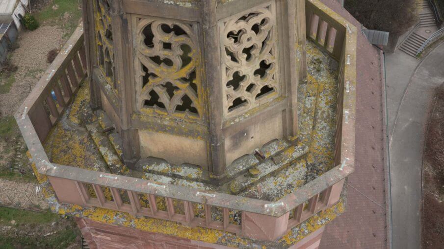
Façade documentation using UAVs
The logging, documentation and depiction of difficult-to-access façades is simplified significantly using UAVs. Highly detailed individual images or 2D orthomosaic photos can be produced with little effort. In addition to the depiction of historical or tall buildings, for example, damage to façades can be mapped and analysed in the best possible way. Three-dimensional views (3D models) can also be processed by us. The data is also used for 3D CAD modelling.
Bridge documentation using UAVs
The inspection of roofs represents a challenge in most cases. When it comes to large and difficult-to-access roof surfaces, the inspection quickly becomes a time and cost-intensive undertaking. Using modern UAVS (drones) and appropriate cameras, the depiction, inspection and documentation of roofs can be significantly shortened and simplified. In addition to the conventional recording of data material, we also offer you the option of live-image transmission, by means of which you can perform inspections in real-time.
UAV roof inspection using high-resolution individual images and/or textured point clouds of live HD image transmission
The inspection of roofs represents a challenge in most cases. When it comes to large and difficult-to-access roof surfaces, the inspection quickly becomes a time and cost-intensive undertaking. Using modern UAVS (drones) and appropriate cameras, the depiction, inspection and documentation of roofs can be significantly shortened and simplified. In addition to the conventional recording of data material, we also offer you the option of live-image transmission, by means of which you can perform inspections in real-time.
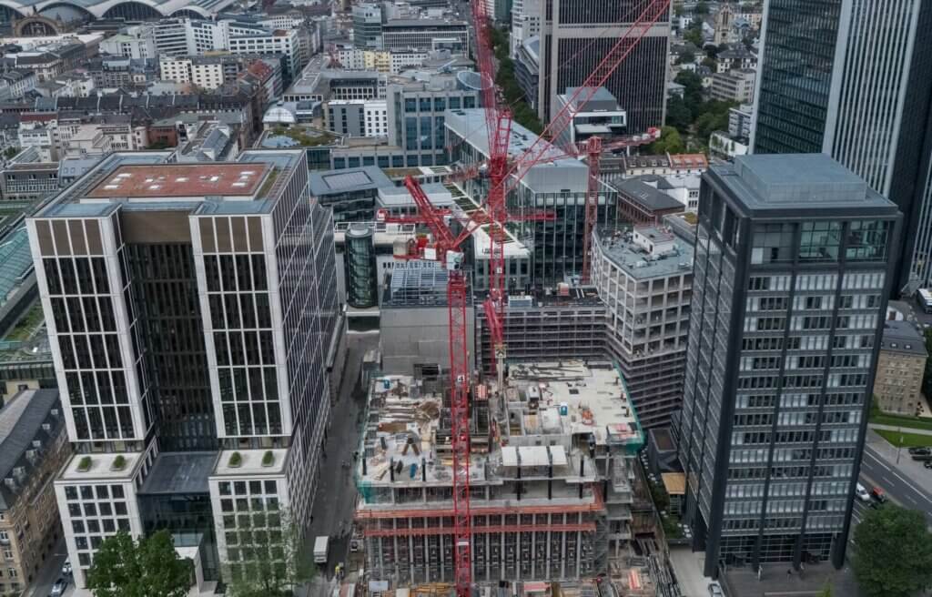
High-resolution aerial images for the construction industry
High-resolution aerial images taken with drones are ideal for marketing purposes, presentations and many other fields of application at the construction industry. Through discussions held in advance, we can narrow down the exact type of pictures you require for your purposes – different angles, flight altitudes, qualities and precisely reproduced flights (GPS-supported) for multiple or later points in time pose no problem at all. We fly outdoors, but also in concealed spaces, in buildings, and underground, such as in tunnels. We therefore offer flexible solutions fully within the limits of your budget.
High-resolution videos from the air for the construction industry
Projects, objects, property and much more can be depicted and presented optimally with mesmerising moving images taken from the air. For this reason, we supply you with high-resolution video material (Full HD – 4K) and pictures with SLR camera quality (24MP) from the air, which can be perfectly used for presentation and marketing purposes – even the transmission of live images is easily possible. We believe that projects, objects, property and facilities can develop their full potential by means of cameras travelling on drones so that they can be presented to buyers, tenants and contracting bodies.
Aerial thermography using UAVs
Our high-performance drones are suitable for transporting and using radiometric cameras, thus providing the opportunity of taking thermographic aerial images in order to find and document energy loss and damaged insulation. Even large areas can be patrolled contact-free, quickly and precisely. The images obtained in this way can subsequently be analysed, further processed and archived by back office staff.
BIM: Advantage of UAV point clouds for building and information modelling at the construction industry
As a relatively new yet already established planning method in the field of civil engineering, building information modelling (BIM) is increasingly attracting attention. Critical to the successful planning and efficient implementation of projects is the quality of the data supplied. Aerial images and point clouds taken from UAVs enable precise monitoring of construction progress as well as target/actual comparisons, which can be evaluated and processed using BIM software.
A UAV point cloud is to be equated with a LiDAR point cloud from a terrestrial scanner and comprises a data record from three-dimensional coordinates, which are defined in X, Y and Z. The BIM data is generated with our UAVs using two methods: photogrammetry or LiDAR scanning (laser scanning). Photogrammetry delivers a high density and especially textured point cloud, or coloured dots, which can be meshed to form a realistic model (wireframe model or volume model). Above all, however, the point cloud provides an ideal design template, which simplifies the CAD modelling process enormously.
UAV point clouds offer the continuous supply and transmission of colourful, detailed and centimetre-precise data for BIM applications for the visualisation, analysis, measurement and controlling of projects. This is possible and recommended from the earliest phase (e.g. the surveying for the preliminary planning or visualisation of existing conditions) right through to the end of the project and beyond.
As already explained, our BIM data records are based on point clouds which are combined with point clouds from other sensors which are usually located on site and are deployed on the ground or internally (e.g. terrestrial LiDAR scanners). Furthermore, the UAV point clouds from LOGXON are usually georeferenced or can be referenced using available or pre-existing BIM point clouds.
We offer a precision from ten centimetres down to the sub-centimetre range. Gathered BIM data can therefore not merely be used for CAD modelling, but also, for example, for delta calculations in order to measure progress or to produce target/actual comparisons in BIM software. Quantity/volume calculations and simulations based on drone data can also be performed seamlessly.
A particular strength of colour BIM data is in the enormous potential for visualising a project or its status faithfully, promptly and in detail. From this, images, videos or animations can be generated which can be used for presentations or documentation for builders, partners, potential buyers or investors.
Besides our services at the construction industry you can find more drone services HERE
We would be delighted to provide you with a tailored and non-binding offer. Please feel free to use our PROJECT QUERY page to submit a query.