Our UAV services in the field of engineering surveying and geodesy at a glance:
3D measurement with UAVs using UAV photogrammetry, UAV laser scanning and terrestrial laser scanning
- 3D measurement and 3D surveying with UAVs by means of UAV photogrammetry, UAV laser scanning and terrestrial laser scanning
- Point clouds as a result of 3D surveying / 3D documentation
- 3D façade surveying by means of UAV photogrammetry, also in combination with terrestrial laser scanning
- Surveying for volume calculation and quantity surveying from the air using UAVs
Modelling
- Point cloud evaluation for volume calculation and quantity surveying
- Georeferenced orthomosaic photos of the earth surface in a wide variety of scales and resolutions
- Digital terrain models, including digital elevation models (DEM), digital terrain models (DTM) and digital surface models (DSM)
- CAD modelling and BIM models
UAV applications in the field of engineer surveying and geodesy
Point cloud based on raw UAV data or laser scanning (UAV as well as terrestrial laser scanning)
A point cloud is a set of individual measurement points in a three-dimensional coordinate system, which is usually defined by X, Y and Z coordinates. The high density of the point cloud enables the depiction of complex surface structures, objects and the earth’s surface. The point cloud is already the result of a measurement or 3D survey. Dimensions can be deduced, paths measured and surfaces formed directly from the point cloud. Yet additional results, such as georeferenced orthomosaic photos, 2D map material and 3D terrain models with respect to surveying, can also be deduced from the point cloud.
Georeferenced orthomosaic photos
Georeferenced orthomosaic photos are distortion-free and true-to-scale illustrations of the earth’s surface with spatial reference through a pre-defined coordinate system. Georeferenced orthomosaic photos are processed into different scales/resolutions
from aerial images or textured LiDAR data in accordance with the application or purpose of use. Orthomosaic photos serve as the basis for surveying, condition recording and cartography and are best suited for use in GIS software (Geographic Information Systems). They are used frequently in rural and urban planning and for the visualisation of objects, façades and large surfaces.
Digital terrain models based on UAV photogrammetry point clouds
Digital terrain model is a generic term for various types of digital elevation models (DEMs), such as the digital terrain model. The digital terrain model (DTM) is selected when elevation structure is of key importance and only the natural earth surface is required. Elements which are not required or desired, such as vegetation and various objects, are not included or depicted in the model. A digital surface model, or DSM for short, refers to an exact depiction of actual conditions in which not only the surface but also elements located there, such as vegetation and buildings, are depicted. Digital terrain models generally portray very realistic and true-to-scale illustrations of landscapes, surfaces and objects and offer a wide range of application options.
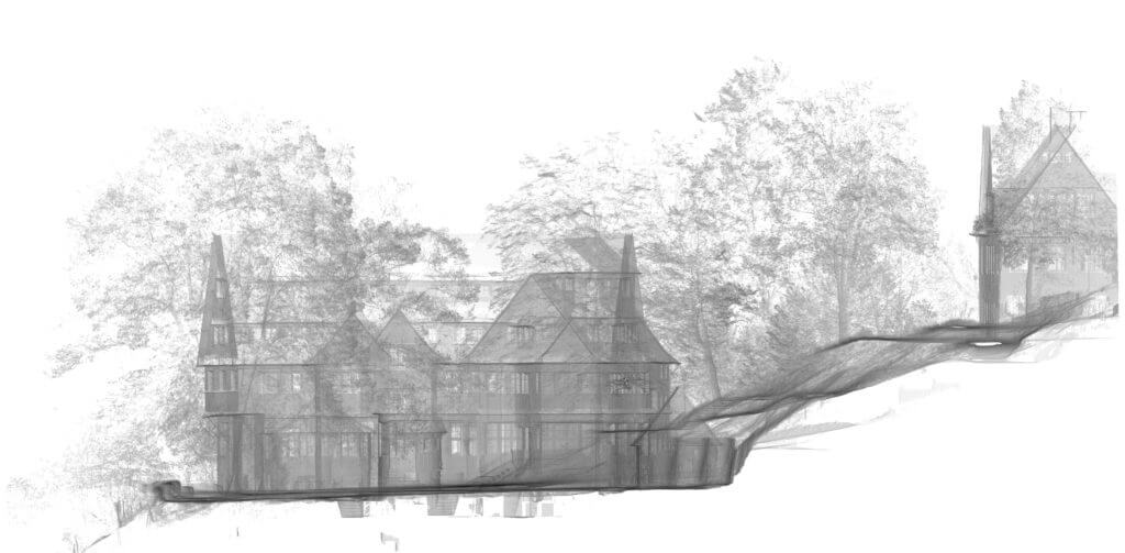
3D façade surveying by using UAVs
For 3D façade surveying and condition recording, the use of UAVs is often unavoidable in terms of efficiency and especially when it comes to tall buildings. The drawing of 3D CAD models, façade plans or the creation of orthomosaic photos (orthophotos) based on a point cloud or CAD-compatible data records is effortlessly feasible. Depending on the project requirements, we employ different methods to enable the fast, contact-free and high-precision capturing (3D measurement) of the façade. The combination of photogrammetric logging and LiDAR scanning (UAV LiDAR or terrestrial scanners) delivers especially good results.
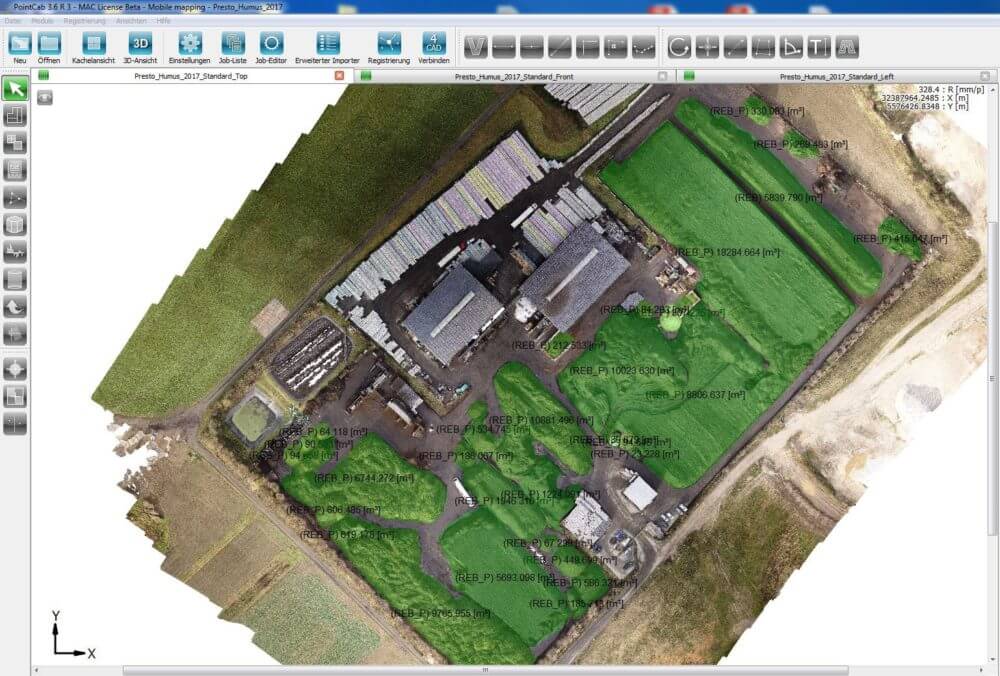
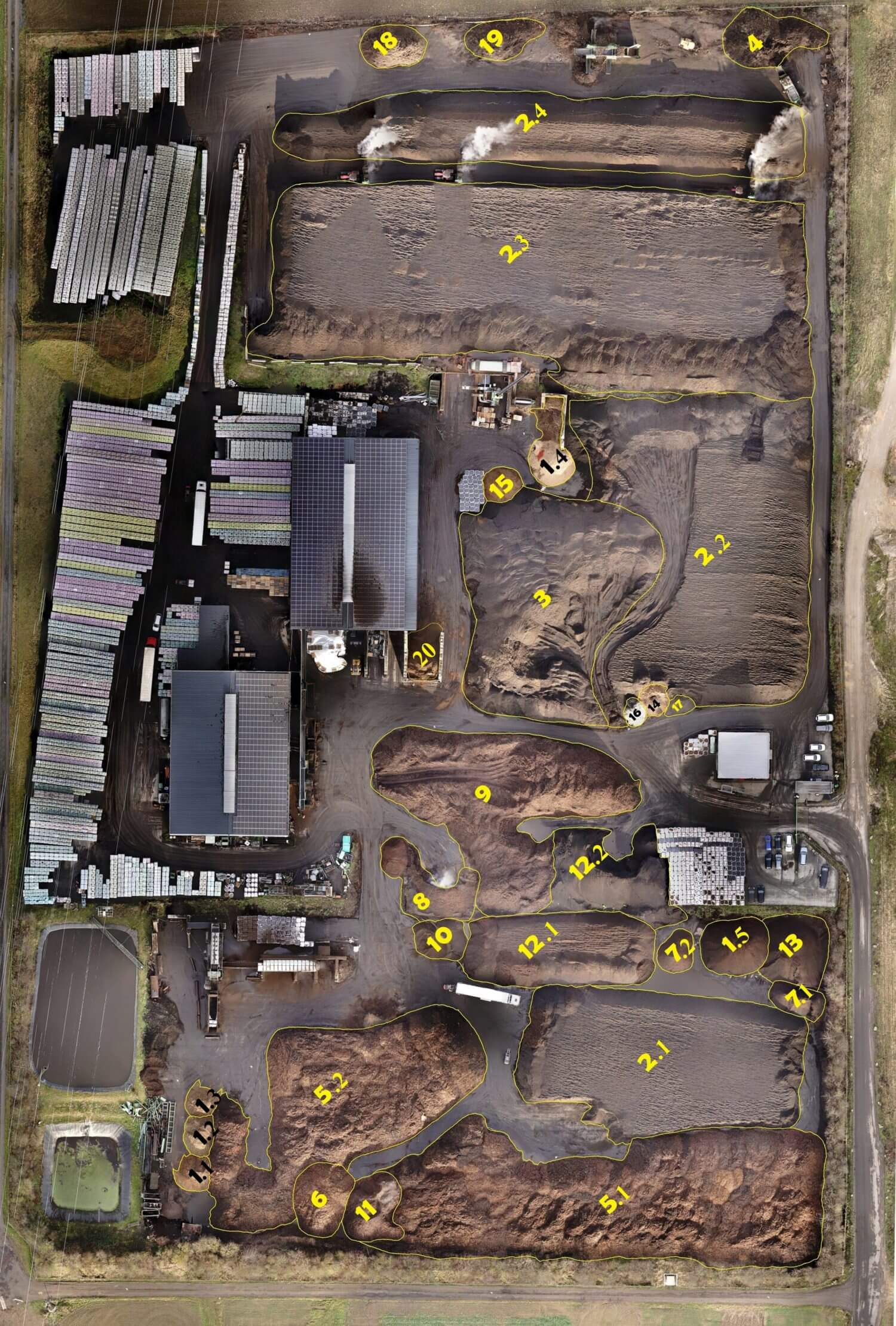
Volume calculation and quantity surveying using UAVs
The recording of data for volume calculations is complex and mostly very imprecise when using conventional measurement methods. Our UAVs enable us to obtain three-dimensional surface data efficiently, safely and digitally. We process high-precision 3D volume models in the shortest possible time (by means of 3D meshing based on a point cloud). In addition to 3D logging, we also offer full data evaluation and deliver numerical documentation of the respective volumes for quantity surveying. The handover of raw data (point cloud or 3D mesh model / wireframe model) for external evaluation is also possible. Furthermore, we produce an orthomosaic photo if it is necessary for orientation or for defining materials and/or storage spaces. By means of two or more flights at different times, we can portray and document an accurate delta (difference comparison) of volume and quantity changes; the same goes for target/actual comparisons from two flights.
Use of UAV data in geographic information systems (GIS)
Like orthomosaic photos, digital terrain models (DTM) and digital surface models (DSM), UAV data is intended for use in geographic information systems (GIS software) and can be output in all common formats. The spatial data logged through UAV flights can thus be interpreted, managed, processed and evaluated effortlessly in GIS. Optimum size and resolution is decisive for efficient use of geodata from the air in GIS software. This is why discussing all data formats and quality requirements beforehand, in order to be able to work with it systematically and efficiently following logging, is of crucial importance.
You can find the various drone services HERE
We would be delighted to provide you with a tailored and non-binding offer. Please feel free to use our PROJECT QUERY page to submit a query.